AD (728x90)

  • 2793 Pine St

    2793 Pine St

    Nulla facilisi. Cras blandit elit sit amet eros sodales, non accumsan neque mollis. Nullam tempor sapien tellus, sit amet posuere ante porta quis. Nunc semper leo diam, vitae imperdiet mauris suscipit et. Maecenas ut neque lectus. Duis et ipsum nec felis elementum pulvi...

  • 1100 Broderick St

    1100 Broderick St

    Nulla facilisi. Phasellus ac enim elit. Cras at lobortis dui. Nunc consequat erat lacus, a volutpat nisi sodales vitae. Phasellus pharetra at nulla in egestas. Vestibulum sit amet tortor sit amet diam placerat tincidunt sit amet eget lorem. Phasellus ...

  • 868 Turk St

    868 Turk St

    Nulla facilisi. Phasellus ac enim elit. Cras at lobortis dui. Nunc consequat erat lacus, a volutpat nisi sodales vitae. Phasellus pharetra at nulla in egestas. Vestibulum sit amet tortor sit amet diam placerat tincidunt sit amet eget lorem. Phasellus posuere posuere fel...

  • 420 Fell St

    420 Fell St

    Sed at vehicula magna, sed vulputate ipsum. Maecenas fringilla, leo et auctor consequat, lacus nulla iaculis eros, at ultrices erat libero quis ante. Praesent in neque est. Cras quis ultricies nisi, vitae laoreet nisi. Nunc a orci at velit sodales mollis ac ac ipsum. Na...

Showing posts with label GPS. Show all posts

Thursday, February 25, 2010

High Tech Goggles Incorporate GPS, Camera, Kitchen Sink


Recon Instruments and Zeal Optics are joining forces to bring us the most high tech ski goggles you've ever seen. Dubbed the Transcend GPS Goggle, the new eyewear incorporates a GPS chip with a built in heads-up display to give you on the fly information about your current location, speed, altitude, and a whole lot more. Navigation is handled by a couple of buttons located on the side of the unit, and data can be saved and viewed on your computer, as well as uploaded to the Internet to compare and challenge friends.

According to the promo video below, the goggles will include a camera for capturing photos and video on the mountain, as well as navigational information such as trail maps and resort specific runs, information on traffic on the slopes, queues for the lifts, tracking your buddy's location, and so much other stuff that even James Bond would be jealous.Reportedly, the goggles will be on sale on October 1st of this year, and you can pre-order now. The regular version will set you back $350, but for $100 more you can order a pair with lowlight and polarized lens.

Reading through the marketing info on the Transcend googles leaves you with a lot of questions. For instance, how does it feed all of that information to the googles themselves? Does it have bluetooth tethering to a smart phone or does it require its own data connection of some type? Obviously the GPS stuff is loaded on a chip, but real time updates on conditions on the mountain require something more. Still, these look really cool, and would be a lot of fun to play with. They certainly seem a lot nicer than those GPS gloves I wrote about last week.

Thursday, February 18, 2010

GPS In A Glove! Why? Why Not?


Yesterday we had a sweet new camera that integrated a GPS chip into to track your location while filming. Today, we've got a new pair of gloves that do the same.

Zanier Gloves has recently announced their Xplore.XGX glove that will include a fully functional GPS chip, allowing skiers to track their speed, distance, and duration on the slopes, as well as altitude changes and route information. The gloves will also provide basic navigation as well, although I'd guess that means using waypoints and a digital compass. Don't expect any kind of map integration. At least not on this year's model.

The functionality of the gloves doesn't end after you get back to the car either. You can plug them into your computer via USB and upload your data to the web to track your progress and plot your route on maps. You can even share the data from your latest ski expedition with your friends.

Aside from the high tech gadgetry that includes a screen with continually updated information the gloves look like a nice piece of gear. They're made of Gore-Tex, and designed to be comfortable and warm, while still allowing us to get a solid grip on our ski poles or other gear that we need to grab.

Seems like we're putting GPS into everything these days. Kind of a cool product, but I can't help but think that a fully functional handheld GPS device might not be a better buy. With no release date or price set on the gloves just yet, it's hard to know for sure, but I'm guessing these won't be cheap.

Tuesday, January 5, 2010

Send Text Messages From The Most Remote Places On The Planet!


We're on the eve of the annual Consumer Electronics Show, when all kinds of new, hot gadgets and gizmos are unveiled to the public who can't wait to get their hands on the latest technology. Everything from new TV's, computers, and home theater systems will be on display in Las Vegas, with impressive price tags to go along with the flashy new products.

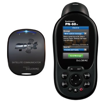
One new item that may be of benefit to outdoor enthusiasts, adventure travelers, and explorers heading to the ends of the Earth. The new device comes to us courtesy of GPS company DeLorme and SPOT, who have teamed together to create the DeLorme Earthmate PN-60w which is paired with a SPOT Satellite Messenger, and allows us to send custom text messages from remote places not typically covered by cell phone service.

The Earthmate offers up a bunch of standard GPS functionality including a 32-channel GPS chipset, a dual-core processor, 3-axis electronic compass, sensitive barometric altimeter, elevation profiles, and GPX file transfers. How much it will cost, and what the price of the service from SPOT will be, remains to be seen, but when the two devices are used in tandem, they'll be able to send text messages, signal emergency services when necessary, and allow others to track your progress as you go.

According to this story at the PC World Blog, both DeLorme and SPOT have more connected devices to show off at CES, so expect to see some similar deices in the days ahead, and have pricing announced too.

Very interesting and potentially useful products. The ability to send a message back from the wild has some great promise, and I can't wait to find out more about this.

Tuesday, December 8, 2009

Gear Box: Nat. Geo. Topo Software


I recently had the opportunity to check out a new software mapping package from National Geographic's TOPO! line of software. which is touted for giving us the ability to create and print our own custom trail maps. The software is a powerful tool that offers a ton of options and details, and should prove very helpful for hikers and backpackers who are planning outdoor adventures in the areas covered by the various packages.

The version of the software that I was sent covers the Moab area of Utah. The region is one of the best in the country for hiking and mountain biking, and the maps included on the CD cover such national parks as Arches and Canyonlands, two popular, but lesser known destinations. The area covered also stretches into the Grand Junction region of Colorado as well, offering amazingly detailed topographic maps that include roads, trails, and points of interest such as campsites, paddling launch sites, scenic overlooks, and much more.

The software allows for multiple levels of zooming, so you can set the level of detail on your custom maps, while also easily adding 3D and topographic profiles to the mix as well. Additionally, you can add your own custom notes or pre-created ones, draw your own routes, and a lot more. And when you've constructed your perfect map, it can be saved to a simple file format and shared with others or printed out to accompany you on your next hike. If you have a handheld GPS, routes and way points can be uploaded to it as well, making it even easier to take your map with you.

While the software is indeed powerful, it comes with a bit of a learning curve, and it takes a bit of practice to put it all together. The interface on the software takes a bit of getting use to, but the manuals, found on the CD in .pdf format, and the online help system help ease the process some. And once you do have a grasp of the system, you'll be building well designed and informative maps in no time.

One of my favorite tools included with the Topo! Maps package is the Trail Chart. Selecting this option, gives you a new window that has a list of all the trails found on the map. The Trail Chart also indicates the type of trail (hiking, jeep, etc.), as well its name, location, and length, along with a brief description. Clicking on any one of the trails takes you directly to it on the map, making it simple to find a hike or ride very quickly. It's a great resource, even if you aren't going to print any of the maps.

The TOPO! software is available for both Mac and PC, and the are both found on the same disc. I used the Mac version, and while it was easy to run the program directly from the disk without installing, I found that performance improved dramatically when I ran from the hard drive instead. I'm also running the latest version of Snow Leopard (10.6.2) and that was causing issues with some of the icons and graphics displaying properly, but a recent update has cleared up this issue, so I recommend you use the "Check For Software Updates" option from the "Help" menu on which ever version of the software you're running.

The MSRP on the TOPO! software is $24.95, with a number of different options available in the National Geographic Store. With the holidays quickly approaching, this is a great stocking stuffer for the backpacker on your list.

In compliance with the new rules governing reviews by bloggers, I am letting everyone know that this software was provided to me by National Geographic for review. As always with Nat. Geo. however, they allow me to write my thoughts without conditions. They continue to provide great products, and I simply write my thoughts. :)

Monday, November 2, 2009

It Is GPS Day At Gadling


In recent weeks we've had a string of "theme days" over at Gadling.com, the travel blog that I write for in addition to this one. Today's theme is GPS+Travel, which seems like a natural fit. These days, many of us have GPS devices in our cars, and they help us to safely and efficiently navigate our way around our home towns as well as our destinations when we travel.

But as many of you know, there is a huge difference between the GPS systems we keep in our cars and the ones that we put in our backpacks when we head out onto a trail. That is essentially the topic of my contribution today at Gadling, where I share some thoughts on the limitations of hand held GPS devices in the backcountry, where there is no such thing as "turn-by-turn" navigation and strict adherence to the GPS unit can get you into very big trouble.

In the article, I tried to stress the importance of learning how to use a map and compass to navigate, and not becoming too reliant on your GPS device. While the high tech navigational units can be very accurate and extremely helpful, the fact that it needs fresh batteries on a regular basis or may not be able to pick up a signal with the overhead satellites, can limit its functionality in the field at times.

Many people are also surprised to learn that when they get out on the trail, their hand held device doesn't give them precise, "turn-by-turn" directions to their intended campsite or that scenic overlook they want to hike to. They still need some essential back country navigational skills to get from Point A to Point B, and far too many people are lacking in those skills are are too trusting of the GPS, which can lead to problems.

You can read more of my thoughts on the subject by clicking here.

Thursday, September 11, 2008

Bushnell Releases Backtrack, simplest GPS Yet!


Checkout the new Bushnell Backtrack, a GPS device that does away with all the color touchscreen, MP3 playing, XM satellite receiving madness we've seen in other GPS units recently. This is minimalist technology at it's finest.

Powered by two AAA batteries, the Backtrack operates as a self calibrating digital compass, along with it's ability to tag a location and then help you find your way back to that spot. Simply mark your campsite when you leave in the morning, and when you're ready to head back, tell the device to "backtrack" and you're on your way. It'll even countdown the distance until you've arrived back where you started. The weatherized device is small enough to slip into your pocket or wear on an included lanyard, and can mark up to three locations to store in it's memory.

The MSRP on the Backtrack seems to be about $75, but as OhGizmo notes, it can be had from Amazon.com for a mere $59.99. Not bad at all. Seems like a great little device to keep on hand. Wonder what the battery life is like on this thing.

Thanks to The Goat for this one.

Friday, July 11, 2008

More GPS Love From Garmin


Hot on the heels of their very well received Colorado 300 and 400 GPS devices, it looks like Garmin is ready to drop a couple of new handhelds on us.

According to this story over at Gizmodo we can expect a new line of GPS units dubbed the "Oregon" line which don't really appear to vary that much from their "Colorado" counterparts. The units share similar screens and functionality although these new models are slightly smaller, even if they aren't all that much more affordable. Gizmodo lists them at $450 for the Oregon 200 and $600 for the Oregon 400.

By most accounts, the Colorado series are pretty great units. The bright screens and touch interface makes them easy to navigate and the built in maps are fairly detailed and accurate. They also offer a host of options for what ever activity you're into from hiking to geocaching to navigating the coast lines. I guess we'll have to wait and see what the "Oregon" units bring to the table if anything.

Wednesday, June 18, 2008

The Garmin NuviFone In Action!


A few months back I blogged about Garmin announcing that they were getting into the smartphone market with a product called the "NuviFone" which was suppose to combine their excellent GPS products with a great cell phone. At the time I talked about how cool a product it could be, but that there were a lot of questions surrounding the device as well.

Well, fast forward a few months and we get our first shots of the NuviFone in action with it's OS running, and I have to say, it looks pretty darn nice. This video is courtesy of Laptop Magazine and it gives us about five minutes of footage of the Nuvi in action.

Judging strictly from the video, I have to say that I'm pretty impressed. It looks like it's shaping up to be a really great product, with navigation at it's core, but also working as a nice cell phone, media player, and Internet device. The screen is clear and bright, with the obvious iPhone influence. Still no word on who the carriers will be, and the price is rumored to be about $500, which sounds on the pricey side with the 3G iPhone clocking in at $199. Still, this is a different device with a different focus and a good handheld GPS is going to cost you in the neighborhood of 500 bones anyway.

Check it out. What do you think?

Friday, February 29, 2008

Garmin Colorado GPS Review


Tom from Two-Heel Drive pointed me towards this excellent review of the Garmin Colorado 400t GPS over at Calipidder.com.

The review is exceptionally well done, with lots of nice details, and an in depth look at this device, which comes with built in topographic maps of the entire United States, and a base map that covers the World. It also has a unique navigation system that uses a click wheel not unlike that of an iPod. I've been eyeing one of these for some time, but haven't had the chance to play with one yet, so this review was great at telling me what the Colorado does well and what it needs some work on.

Reviewer Rebecca puts the Colorado through it's paces on a trail run and geocaching, and after a short 24 hours of use, she's completely sold on the new device. From her report, the maps are good, the tracking is accurate, and it had more features then you can shake a stick at. She goes on to say that she intends to use the Colorado for backcountry navigation and more geocaching, which the unit does very well, but has capabilities that extend far beyond those uses as well.

Hmm... I just got my REI dividend as well, and I received several REI giftcards for Christmas that I still haven't used. Perhaps I should make a trip over to the store this weekend. That is, unless someone over at Garmin wants to send me one to play with! ;)

More on the Colorado 400t here.

Friday, February 1, 2008

Garmin Introduces The Nuvifone


Earlier this week Garmin, the leading manufacturer of GPS devices, threw it's hat into the cell phone ring by introducing the Nuvifone , a device that combines their patented navigation systems with a smartphone.

The device runs on Garmin's proprietary operating system, and is clearly focused on naviation first, but also has the ability to surf the web, check your e-mail, and instant message your friends. The Nuvifone will aslo play MP3 and video files, comes with a built in camera for both still and video shots, and features Google Local searches. Going one step further however, the little gadget will connect with Garmin's Online Services, providing real time traffic updates, weather conditions, gas prices and more.

While no carriers have been announced yet for the nFone, it's technology is built around GSM HSDPA technology. That means, that at the moment, the only provider capable of offering it is AT&T, although T-Mobile will roll out HSDPA soon as well. The device is expected to be released in the 3rd quarter of this year, but a price has not been announced yet either.

This looks like an interesting device, and it'll be interesting to see how it operates. A lot of companies have tried to create cell phones in recent years, but few have managed to get the delicate balance of phone, media player, internet device, and other features just right. As an owner of an iPhone, I can honestly say that I completely love it as a tool for making my day to day life easier, but I'm also quite curios as to how his will turn out for Garmin. Obviously navigation will be really good on it, but how well will the other features work? What will the battery life be? The voice quality? Will it challenge the Blackberry in e-mail services or the iPhone on web browsing and media playback. I guess we'll just have to wait to see.

Wednesday, August 29, 2007

Cycling Centric GPS Units From Garmin


A few weeks back the Magellan faithful received some good news in the form of the Triton line of GPS units due out this Fall. Not to be out done however, the Garmin camp now have some new units to look forward to as well, although they are aimed more at the cyclist than the backpacker.

According to Engadget the new Edge 605 and 705 GPS units are both bike mountable for navigating while you ride. They'll also keep track of your distance, time, calories burned, altitude, rate and amount of climb and descent and more. They'll also allow you to collect data on your rides and track your performance over time. The high end model, the 705, also has optional add-ons such as a heart-rate sensor and cadence monitor.

One of the other cool features that both units have is the ability to race a "ghost" opponent over a set distance or time, and if the ghost isn't proving up to the task, you can also race against your previous rides on a given course, with the GPS unit keeping track of where you are in relation to your past times.

Currently the two units are set to ship in December, just in time for that cycling enthusiast on your Christmas list. Retail prices are $399 for the 605 and $499 for the 705. The 705 will also be available in packages with the optional add ons in prices ranging up to $649.

Wednesday, August 8, 2007

Gearbox: New GPS Love From Magellan


Check out this new line of handheld GPS devices from Magellan. According to Electronista these new units, known as the Triton line, will come with full color, touchscreens, maps supplied by National Geographic, as well as all the other bells and whistles associated with Magellan hendhelds, including ruggedized design, and full water proofing.

However, the six units that comprise the Triton series, will come with a variety of other options, including built in barometers to monitor the weather, SD card slots for expansion, built in 2 mega-pixel cameras, and LED flashlight, and more. The top of the line unit, the Triton 2000, even includes a speaker and a microphone, so I'm guessing it can be used to play back MP3 files and make voice recordings as well. The built in maps can be updated with more detailed ones with internal memory and the SD card slot. These devices mark the first time that National Geographic has made their maps available for use in a handheld as well.

The Triton series will be available next month, with the entry level unit, the Triton 200, starting at $129 sans card slot, barometer, and rechargeable batteries. The mid-rainge unit, the 500, will retail for $249, and should contain most options except the camera and flashlight, while the 2000 tops out the series with a retail price of $499.

These look like some really great new GPS units. It'll be interesting to see how they integrate the touchscreen technology, which works great in products like the iPhone. My aging Magellan is due for an upgrade, and this looks like it might fit my needs nicely. I'm not sure I need a digital camera or flashlight on my GPS device, but the maps options, expandability, and other features sound great. Just what I needed! More gear to lust over!

Feature (Side)

© 2013 . : : Machu Picchu : . All rights resevered. Designed by Templateism